- Title
- Forest loss
- Description
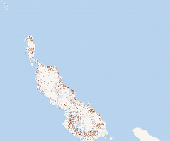
Forest loss dataset extracted from Hansen global forest cover change dataset. the data shows the forest loss between 2000 and 2020.
- License
- Creative Commons Attribution for Intergovernmental Organisations (CC BY-IGO) (CCBYIGO)
-
+ Under the CC BY-IGO license, you are free to share (copy and redistribute the material in any medium or format) and or adapt (remix, transform, and build upon the material) for any purpose, even commercially. The licensor cannot revoke these freedoms as long as you follow the license terms. The license terms are that you must give appropriate credit, provide a link to the license, and indicate if changes were made. You may do so in any reasonable manner, but not in any way that suggests the licensor endorses you or your use. Additionally, you may not apply legal terms or technological measures that legally restrict others from doing anything the license permits. When the Licensor is an intergovernmental organization, disputes will be resolved by mediation and arbitration unless otherwise agreed.
+ For more info see https://creativecommons.org/licenses/by/3.0/igo/legalcode. - Publication Date
- Nov. 15, 2013, 4:59 p.m.
- Type
- Raster Data
- Category
- Forests
- Forests
- Regions
- Papua New Guinea
- Approved
- Yes
- Published
- Yes
- Featured
- No
- DOI
- None
- Attribution
- Hansen et al
- Name
- admin
- undp.png.im@gmail.com
- Position
- None
- Organization
- None
- Location
- Voice
- None
- Fax
- None
- Identification Image
-


- Spatial Extent
- ---
- Projection System
- EPSG:4326
- Extension x0
- 154.0994441761074
- Extension x1
- 157.0380131335192
- Extension y0
- -6.881011861261591
- Extension y1
- -4.355308608431145
- Maintenance Frequency
- Data Is Updated Every Year
- Restrictions
- Other Restrictions
- Language
- English
- Data Quality
Results from time-series analysis of Landsat images in characterizing global forest extent and change.
- Supplemental Information
https://data.globalforestwatch.org/documents/14228e6347c44f5691572169e9e107ad
- Spatial Representation Type
- raster
- Name
- admin
- undp.png.im@gmail.com
- Position
- None
- Organization
- None
- Location
- Voice
- None
- Fax
- None
- Link Online
- /layers/BGV_forestloss:geonode:BGV_forestloss
- Metadata Page
- /layers/BGV_forestloss:geonode:BGV_forestloss/metadata_detail
- Original Dataset
- Forest loss.zip
- JPEG
- Forest loss.jpg
- GeoTIFF
- Forest loss.geotiff
- Thumbnail
- Forest loss.png
- Legend
- Forest loss.png
- Forest loss.pdf
- PNG
- Forest loss.png
- Legend
- Forest loss.png
- Thumbnail
- Forest loss.png
- OGC WMS: geonode Service
- Geoservice OGC:WMS
- OGC WCS: geonode Service
- Geoservice OGC:WCS
- Name
- bissmella
- Position
- None
- Organization
- None
- Location
- Voice
- None
- Fax
- None