- Title
- Intact Forest Landscapes 2000 / 2013 / 2016
- Description
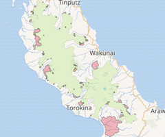
An Intact Forest Landscape (IFL) is an unbroken expanse of natural ecosystems within the current forest extent, with no remotely detected signs of human activity, and large enough that all native biodiversity, including viable populations of wide-ranging species, could be maintained. For the purposes of our global assessment, an IFL is defined as a territory which contains forest and non-forest ecosystems minimally influenced by human activity, with (i) an area of at least 500 km2 (50,000 ha), (ii) a minimum width of 10 km (measured as the diameter of a circle that could be entirely inscribed within the boundaries of the territory), and (iii) a minimum corridor/appendage width of 2 km. Areas with the evidence of certain types of human influence are considered disturbed or fragmented and consequently not eligible for inclusion in the IFL.
- License
- Creative Commons Attribution International(CC BY) (CCBY)
-
+ Under the CC BY license, you are free to share (copy and redistribute the material in any medium or format) and or adapt (remix, transform, and build upon the material) for any purpose, even commercially. The licensor cannot revoke these freedoms as long as you follow the license terms. The license terms are that you must give appropriate credit, provide a link to the license, and indicate if changes were made. You may do so in any reasonable manner, but not in any way that suggests the licensor endorses you or your use. Additionally, you may not apply legal terms or technological measures that legally restrict others from doing anything the license permits.
+ For more info see https://creativecommons.org/licenses/by/4.0/legalcode. - Creation Date
- July 6, 2017, 12:34 a.m.
- Type
- Vector Data
- Keywords
- Category
- Forests
- Forests
- Regions
- Pacific, Papua New Guinea, Bougainville
- Approved
- Yes
- Published
- Yes
- Featured
- No
- DOI
- None
- Attribution
- Greenpeace, University of Maryland, World Resources Institute and Transparent World.
- Name
- Theresa Dearden (theresa)
- Position
- None
- Organization
- UNDP
- Location
- Voice
- None
- Fax
- None
- Identification Image
-


- Spatial Extent
- ---
- Projection System
- EPSG:3857
- Extension x0
- 17226653.831
- Extension x1
- 17302024.1382
- Extension y0
- -712455.3337999992
- Extension y1
- -617826.882199999
- Maintenance Frequency
- There Are No Plans To Update The Data
- Purpose
The global IFL data provided in the ArcGIS shapefile format in geographic coordinates using the WGS84 coordinate system. The recommended scale for data visualization is 1:1,000,000. The dataset includes four layers: the IFL extent for the years 2000, 2013, and 2016 (ifl_2000.shp, ifl_2013.shp, and ifl_2016.shp) and the aggregate IFL change layer (ifl_2000_2013_2016.shp). The year 2000 dataset contains the unique IFL patch ID combined from the IFL region code (see table below) and unique ID within the region, e.g. “AFR_25”. The same ID was retained for the year 2013 and 2016 datasets; however, in case IFL patch was fragmented into separate patches, an additional unique index was added to the IFL ID, e.g. “AFR_25_1”, “AFR_25_2”, etc. The area of IFL patches estimated in the equal-area Hammer-Aitoff projection and provided in thousands of hectares. Due to the limitations and possible uncertainties in exact area estimation, the actual area threshold for the IFL patch inclusion was 49,000 (instead of 50,000) hectares.
Regional abbreviations
Africa
AFR
Australia and New Zealand
AUS
North and Central America
NAM
Northern Eurasia
NEA
South America
SAM
South-East Asia
SEA
The ifl_2000_2013_2016.shp layer has [CLASS] database filed used as the IFL date identifier:
IFL2000 – IFL areas that were fragmented or degraded by the year 2013
IFL2013 – IFL areas that were fragmented or degraded by the year 2016
IFL2016 – IFL areas for the year 2016
The ifl_change_2000-2013.shp layer provides information on the proximate cause of IFL area loss for the 2000-2013 interval. A similar dataset for the 2013-2016 interval will be released later. Each polygon in this layer has the following information (DB fields):
[CLASS_NAME] A proximate cause of IFL area loss, with the following values:
IFL loss 2000-2013 - non-fire related fragmentation/alteration.
IFL fire-related loss 2000-2013 - fire related fragmentation/alteration.
IFL2013 - polygon remains as IFL.
[IFL13_ID] An IFL ID in the year 2013 (if the area considered as remaining IFL).
[IFL00_ID] An IFL ID in the year 2000.- Language
- English
- Supplemental Information
Greenpeace, University of Maryland, World Resources Institute and Transparent World. “Intact Forest Landscapes 2000/2013/2016” Available at www.intactforests.org
- Spatial Representation Type
- vector
- Name
- Theresa Dearden (theresa)
- Position
- None
- Organization
- UNDP
- Location
- Voice
- None
- Fax
- None
- Link Online
- /layers/undp_bougainville_data:geonode:ARB_IFL_2000_2013_2016
- Metadata Page
- /layers/undp_bougainville_data:geonode:ARB_IFL_2000_2013_2016/metadata_detail
- Original Dataset
- Intact Forest Landscapes 2000 / 2013 / 2016.zip
- JPEG
- Intact Forest Landscapes 2000 / 2013 / 2016.jpg
- Intact Forest Landscapes 2000 / 2013 / 2016.pdf
- PNG
- Intact Forest Landscapes 2000 / 2013 / 2016.png
- Zipped Shapefile
- Intact Forest Landscapes 2000 / 2013 / 2016.zip
- GML 2.0
- Intact Forest Landscapes 2000 / 2013 / 2016.gml
- GML 3.1.1
- Intact Forest Landscapes 2000 / 2013 / 2016.gml
- CSV
- Intact Forest Landscapes 2000 / 2013 / 2016.csv
- Excel
- Intact Forest Landscapes 2000 / 2013 / 2016.excel
- GeoJSON
- Intact Forest Landscapes 2000 / 2013 / 2016.json
- Legend
- Intact Forest Landscapes 2000 / 2013 / 2016.png
- Legend
- Intact Forest Landscapes 2000 / 2013 / 2016.png
- Thumbnail
- Intact Forest Landscapes 2000 / 2013 / 2016.png
- OGC WMS: geonode Service
- Geoservice OGC:WMS
- OGC WFS: geonode Service
- Geoservice OGC:WFS
- Name
- Theresa Dearden (theresa)
- Position
- None
- Organization
- UNDP
- Location
- Voice
- None
- Fax
- None